Thursday, November 22, 2012

References

References

http://digitalsportsman.com/wetlands/fresh.htm
http://blog.sfgate.com/stienstra/2012/07/08/s-f-s-dirty-little-secret-the-lake-merced-cesspool/
http://www.lmtf.org/FoLM/Data/SFSUReports/water.htm
http://www.lmtf.org/FoLM/Data/monthly_rainfall_level_from_1996.html
http://www.lmtf.org/FoLM/Data/SFSUReports/geology.htm
Map of lake merced found on google maps aerial view

What can be done to resolve this problem?


Certain groups such as the San Francisco Public Utilities Commission and the Department of Public Works created a project to minimize the damage caused by drain runoff. They introduced swales to catch runoff and keep it in the soil. This, however, eventually overwhelmed the soil and made it difficult for more sensitive native vegetation to grow healthily.

The Bay Area Water Supply and Conservation Agency are lobbying a Recycled Water Management Plan. This would create plants around the city to recycle water and minimize the amount of drain runoff. These are the types of solutions we need.

We absolutely can not just minimize the damage done to Lake Merced. What we can do is improve the gutter system itself in order to prevent any more pollutants from entering the lake or the surrounding soil and let nature restore itself. We should also re-open certain channels to replenish the lake with fresh water and further increase the rate of restoration.

But how can we get this done? How can we send the message out that the Lake needs our help? Through awareness. We need to spread the message and help people understand the importance of voting for propositions that help restore Lake Merced. Through awareness and activism, we can bring back the crystal clear waters of Lake Merced for our children.


What kinds of wildlife are being threatened?

The native population of shrimp and marine life have been decimated. One would be lucky to spot a minnow in the murky waters. The pollution and lowered lake level have decimated the native ecosystem. However, we can still preserve the wildlife that is left.

Avifauna
Mainly, avifauna 48 species of birds live in Lake Merced year-round. 8 species use the lake during their nesting season and 13 species may breed or nest at the lake. Many of these birds are endangered or threatened. It is crucial that we take action now and prevent them from falling into extinction. Some of these endangered species include: the bank swallow

the saltmarsh common yellowthroat

 the California black rail

and the American peregrine falcon.

Vegetation
Vegetation played a large role in the formation of the lake. Sand that had been blown from the coast were trapped between the flora and created the dunes that surround Lake Merced. The native vegetation of Lake Merced consists primarily of shrubs and reeds that grow on the edges of the lake. There are a few chaparrals and oaks growing on the sandy dunes as well. Trees primarily line the outer ring of the lake closest to the road.


Consequences
If left unchecked, wildlife at Lake Merced and native vegetation will all but disappear and the city of San Francisco will be left with a toxic, putrid green pool. Not only that, but the vegetation that acted as a sand buffer would be gone and would cost the city thousands of dollars to clean up what the Lake had done for free.

Wednesday, November 21, 2012

What is Lake Merced and why is it being threatened?


Map of Lake Merced


Lake Merced is a freshwater lake that provides habitat for over 200 species of birds, reptiles, amphibians, plants, and fish. It is the only freshwater wetland in San Francisco. The Department of Fish and Game once reported that Lake Merced had one of the richest marine ecosystems of all the lakes in northern California. The water levels were so high that Lake Merced periodically flushed out to the ocean over the streets of Sloat and Vicente. Water quality was exceptional and tourists were able to relax and enjoy the crystal clear waters while fishing in their tiny rowboats, but no more.
The lake is now being threatened by urban pollution and its marine wildlife has decreased tremendously. Runoff from the streets about the lake have turned the once clear waters into a murky green cesspool. Rounds shot off by members of the Pacific Rod and Gun Club have potentially poisoned the lake with lead. The water level of the lake reduced tremendously during 1950-1990. Surface creeks that had once supplied fresh water to the lake have been diverted and the lake itself pumped to make room for the surrounding golf course and gun range. The Westside Groundwater Basin Water Channel has all but stopped due to urbanization. These along with summer droughts has lowered the water level and intensified the issue of pollution.

Here are pictures of the golf coarse and shooting range around Lake Merced:


Here is a graph of the turbidity of the lake taken from 1980-1999 from the website http://www.lmtf.org/FoLM/Data/SFSUReports/water.htm

It shows that the amount of organic and insoluble pollutants in the water of Lake Merced is increasing to a critical level. If left unchecked, it will soon be too late to restore its waters.

Here is a graph of the acidity levels and alkalinity levels of the lake taken from 1960-199:


The data shows that the lake itself has a basic pH which means high alkaline levels. When I personally took samples from Lake Merced and ran them under litmus paper on November 22nd, 2012, I found the pH level to be between 7-8.3 confirming this data.

Here is a graph of the dissolved oxygen levels of the lake at both the surface and 15 feet under the lake from 1997 to 1999:


This shows a slight decrease in the amount of dissolved oxygen in the lake itself. Many marine organisms rely on a stable dissolved oxygen level. Thus, attributing to the gradual disappearance of much of the marine life in Lake Merced. This problem is caused by the rise in turbidity and the basification of the lake.

Here is a graph of the temperature of the lake at the surface from 1997 to 1999 and 15 feet under the lake from 2000 to 2005:


Temperature is vital to many biological functions in marine life. The temperature shows an inverse relationship with the amount of dissolved oxygen fifteen feet under the lake. Unfortunately, during cold winter periods, many marine wildlife are not able to function in the frigid waters far below the surface.

Here is a graph of phosphorus and nitrogen levels of the lake from 1997 to 1999:


Phosphorus levels are slightly higher than that of nitrogen ammonia probably because of chemical runoff from the nearby streets and golf course, but both levels are quite stable. This means that algal bloom should not be a very detrimental problem in the lake's foreseeable future.

Here is a graph of the lake level from June 1999 to April 2006


This is the most significant issue. It shows a significant downward trend in the water level of the lake and attests to the increased concentration of pollutants. This was also during the period in which marine life began to disappear. However, the level has increased since 2002 due to an addition of "system water." We are currently maintaining a water level of 21 feet. However, this is not a permanent solution as the environment itself has not produced this level of water.

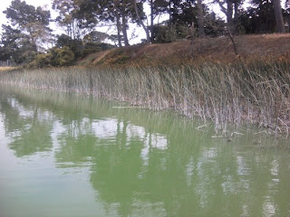
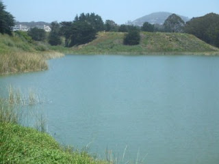
And here is a comparison of the lake today and its former glory:

As you can clearly see, the clarity of the lake and it's nearby vegetation has deteriorated.

What is a freshwater wetland and what kinds are there in northern California?

Let's start with understanding what a freshwater wetland is.
A freshwater wetland is an aquatic habitat that contains non-saline water.
There are 4 main typed of Freshwater Wetlands in North America: Ponds and Lakes, Marshes, Swamps, and Peatbogs

o   A pond or lake is a well-defined basin that is filled with stagnant water and ringed by vegetation. It is fed mainly by rainstorms and snowmelt, and loses most of its water through seepage and evaporation. In hot, dry months, parts of a pond or lake may dry out, exposing mud flats. In shallow ponds or lakes, bottom rooted plants such as water lilies can reach the surface, while milfoils, pondweeds, and other submergent plants thrive below the surface.

o   A marsh is usually found near a river, lake or tidal waters. Marshes are subject to periodic flooding, and the water level can change drastically in a short amount of time. The boundaries of a marsh are not well defined, and in draught, a marsh can completely dry up. Marshes are overgrown with coarse grasses, sedges and rushes.


o   A swamp is essentially a wooded marsh. Unlike Marshes, Swamps can support trees, tall shrubs, herbs and mosses. Swamps are covered with still or gently flowing water during wet seasons.

o   A peatbog is a poorly drained area that is covered by mats of moss, which slowly decompose in successive layers and eventually form a material called peat. There are 2 types of peatbogs; Bogs and Fens. The water of a Bog is much more acidic than that of a Fen, due to the larger quantities of sphagnum moss and the more advanced process of decomposition in a Bog. The vegetation of a Peatbog is mainly Sedges, Spruce and low-growing members of the Heath family.